
Day 3 – Q 5.With the help of suitable examples, discuss various fluvial landforms.
5. With the help of suitable examples, discuss various fluvial landforms.
उपयुक्त उदाहरणों की मदद से, विभिन्न फ्लुविअल लैंडफॉर्म पर चर्चा करें।
Approach:
In Introduction define what is called fluvial landforms
In the body – Give examples of erosion and depositional landforms-along with examples
End with suitable conclusion
Answer
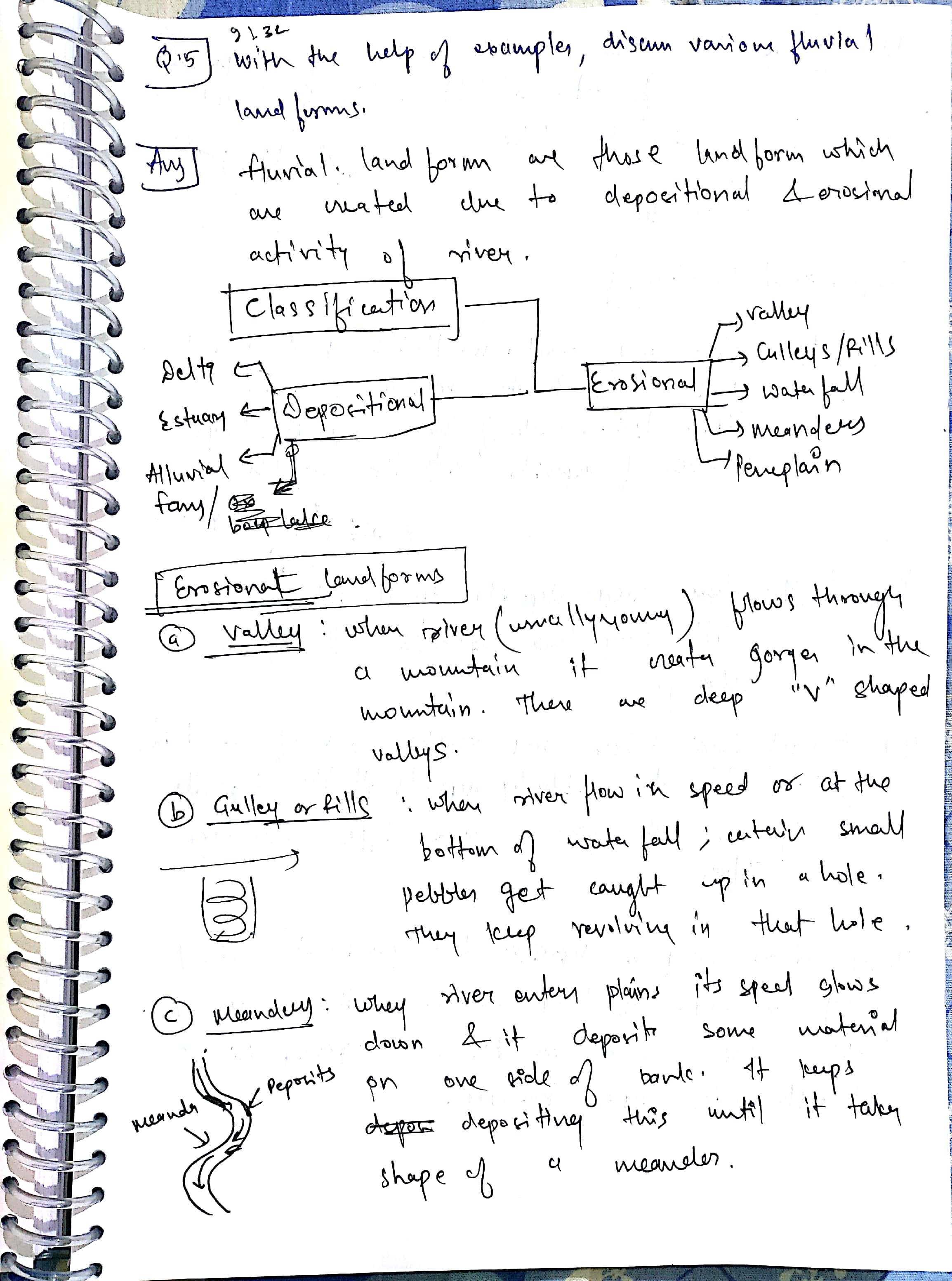
The landforms created as a result of degradation action (erosion) or aggradations work (deposition) of running water is called fluvial landforms.
These landforms result from the action of surface flow/run-off or stream flow (water flowing through a channel under the influence of gravity).
Erosion Landforms
- River valleys: The extended depression on ground through which a stream flows throughout its course is called a river valley. At different stages of the erosion cycle the valley acquires different profiles. At a young stage, the valley is deep, narrow with steep wall-like sides and a convex slope. The erosion action here is characterised by predominantly vertical down cutting nature. The profile of valley here is typically ‘V’ shaped. As the cycle attains maturity, the lateral erosion becomes prominent and the valley floor flattens out. The valley profile now becomes typically ‘U’ shaped with a broad base and a concave slope.

A deep and narrow V shaped valley is also referred to as gorge and may result due to down cutting erosion and because of recession of a waterfall. Most Himalayan Rivers pass through deep gorges (at times more than 500 metres deep) before they descend to the plains. An extended form of gorge is called a canyon-E.g. Grand Canyon Colorado
2) Waterfalls:
A waterfall is simply the fall of an enormous volume of water from a great height, because of a variety of factors such as variation in the relative resistance of rocks, relative difference in topographic reliefs; fall in the sea level and related rejuvenation, earth movements etc. For example, Jog or Gersoppa falls on Sharavati (a tributary of Cauvery) has a fall of 260 metres.
A rapid, on the other hand, is a sudden change in gradient of a river and resultant fall of water

3) Pot Holes:
The kettle-like small depressions in the rocky beds of the river valleys are called pot holes which are usually cylindrical in shape. Pot holes are generally formed in coarse-grained rocks such as sandstones and granites

4) Terraces:
Stepped benches along the river course in a flood plain are called terraces. Terraces represent the level of former valley floors and remnants of former (older) flood plains.

5) Gulley:
Gulley is an incised water- worn channel, which is particularly common in semi-arid areas. It is formed when water from overland-flows down a slope, especially following heavy rainfall, is concentrated into rills, which merge and enlarge into a gulley. The ravines of Chambal Valley in Central India and the Chos of Hoshiarpur in Punjab are examples of gulley.

6) Meanders:
A meander is defined as a pronounced curve or loop in the course of a river channel. The outer bend of the loop in a meander is characterised by intensive erosion and vertical cliffs and is called the cliff-slope side. This side has a concave slope. The inner side of the loop is characterised by deposition, a gentle convex slope, arid is called the slip-off side.

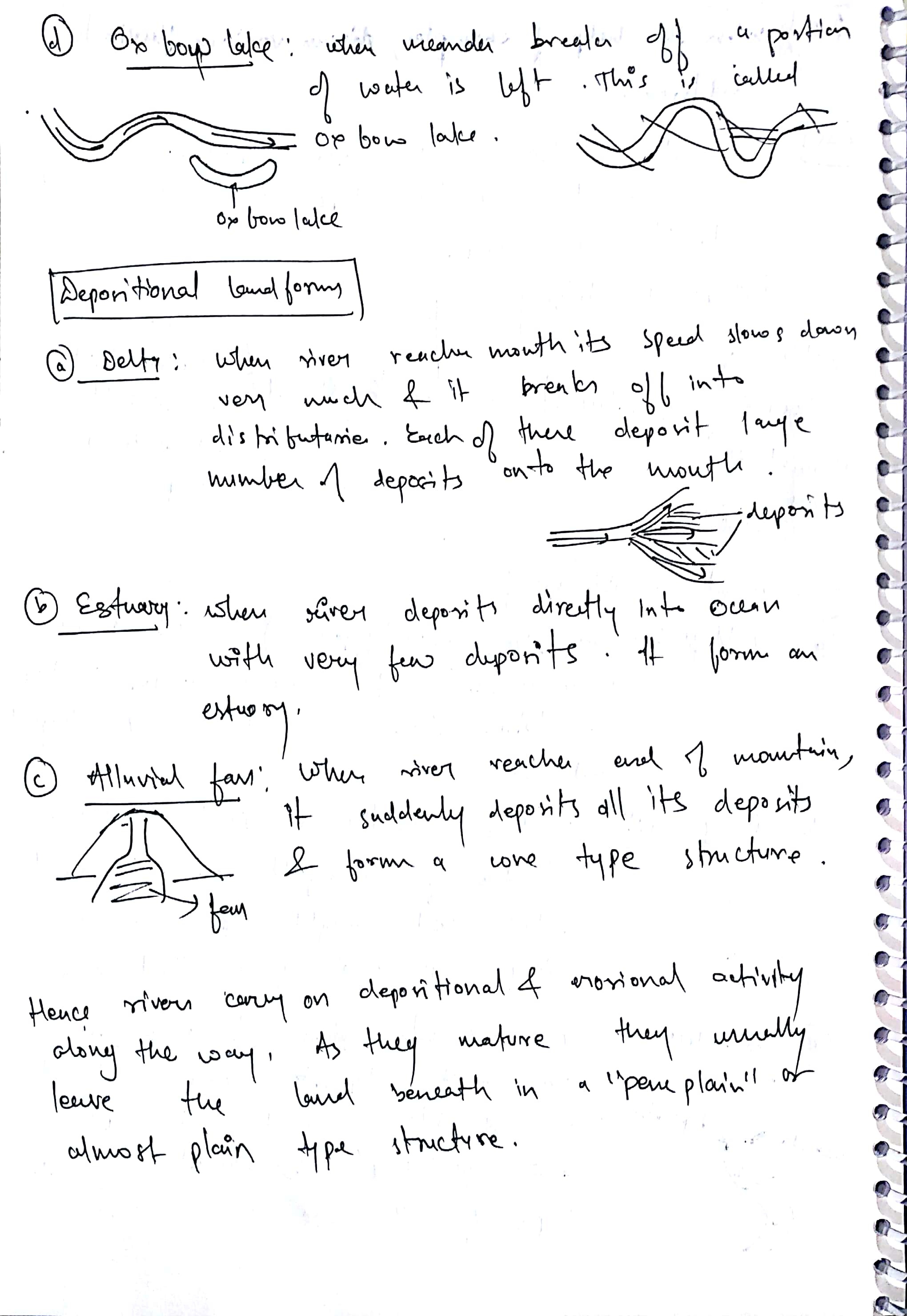
7) Oxbow lakes
The outer curve of a meander gets accentuated to such an extent that the inner ends of the loop come close enough to get disconnected from the main channel and exist as independent water bodies. These water bodies are converted into swamps in due course of time. In the Indo-Gangetic plains, southwards shifting of Ganga has left many ox-bow lakes to the north of the present course of the Ganga.
8) Peneplains:
This refers to an undulating featureless plain punctuated with low- lying residual hills of resistant rocks. According to W.M. Davis, it is the end product of an erosion cycle.
Depositional Landforms
1) Alluvial Fans and Cones:
When a stream leaves the mountains and comes down to the plains, its velocity decreases due to a lower gradient. As a result, it sheds a lot of material, which it had been carrying from the mountains, at the foothills. This deposited material acquires a conical shape and appears as a series of continuous fans. These are called alluvial fans. Such fans appear throughout the Himalayan foothills in the north Indian plains.

2) Natural leeves:
These are narrow ridges of low height on both sides of a river, formed due to deposition action of the stream, appearing as natural embankments. These act as a natural protection against floods but a breach in a levee causes sudden floods in adjoining areas, as it happens in the case of the Hwang Ho river of China.

3) Delta:
A delta is a tract of alluvium usually fan-shaped, at the mouth of a river where it deposits more material than can be carried away. The river gets divided into two or more channels (distributaries) which may further divide and rejoin to form a network of channels

Thus various erosion and depositional landforms are formed by rivers.
Best Answer: John Nash:
